Google Interactive Map
Use the arrows to move about the map.
Use the + and - buttons to zoom in or out.
Other Maps
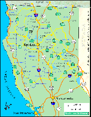
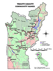
Click either map to view in full size.
Location & Directions
Weaverville Is located in Trinity County of Northern California and nestled at the foot of the beautiful Trinity Alps Wilderness. For GPS users, entering the intersection of CA-3 and CA-299 in the "Trip" function will get you here.
GPS Coordinates:
latitude - 40.731 / longitude -122.942
Weaverville Airport Information:
Phone (530) 623-1365
Driving Directions:
From San Francisco CA
Take I-80 East to I-505 North to I-5 North to Redding. From Redding I-5 take exit 678 / CA-44 West. Follow signs through town to CA-299 West, then stay on CA-299 West to Weaverville.
Driving time: 4 hours 35 minutes.
Distance: 262 miles.
From Eureka CA
Take Take CA-299 East to Weaverville.
Driving time 2 hours
Distance 103 miles.
From Reno NV
Take US-395 North to Susanville CA. Continue on to CA-36 West to CA-44 West / Feather Lake Hwy. Follow CA-44 West to Redding then follow signs through town to take CA-299 West / Eureka Way to Weaverville.
Driving time: 4 hours 32 minutes.
Distance: 243 miles.
From Portland OR
Take I-5 South to Redding CA. Take exit 681B for CA-273 / Market St. Merge on Market St then turn right on CA-299 West / Eureka Way, then stay on CA-299 West to Weaverville.
Driving time: 8 hours 5 minutes.
Distance: 465 miles.


